Thursday, December 6, 2012

New Orleans, Today, Tomorrow, and the End.


Surrounded by three bodies of water; the Mississippi River, Lake Borgne, and Lake Pontchartrain, New Orleans at its highest point sits at a measly 25 feet above sea level.  


New Orleans, virtually surrounded by water.
(http://www.weather-forecast.com/weatherobjects/map/N/New-Orleans.jpg)
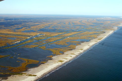
The Mississippi River is responsible for most of New Orleans’ landforms.  New Orleans soil is made up of silt, which comes from run-off from the Mississippi river, which over the years has piled up.  This rich soft soil is constantly covered with water every time the river floods or a storm comes in from the ocean, creating New Orleans unique wetland landscape of swamps, salt-water marshes, and bayous.  The wetlands are brimming with life and help protect the land from the storms and hurricanes that constantly threaten the longevity of New Orleans.

New Orleans geographical location is relatively close to the equator.  Warm weather and intense humidity, which come with such a location, have created New Orleans’ Humid Sub-Tropical Climate.
New Orleans Landscape is constantly changing.  The delicate silt that makes up the soil is easily eroded, and flooding from all sides in an especially storm-prone area of the United States makes New Orleans especially susceptible to erosion and weathering.  New Orleans exists at the bottom of one of the countries largest drainage systems and is vulnerable to flooding at all sides.  Something as simple as snow melting in Minnesota can be responsible for catastrophic flooding in New Orleans.

Path of the Mississippi River
(http://maps.bpl.org/id/10988)

The Next 100 Years.
Due to the make up of New Orleans soil, the flooding of its land, and a poorly constructed levee system, New Orleans is destined to be the victim of disaster in the next 100 years.  The majority of New Orleans is already below sea level, and information gathered by Canada’s RADARSAT satellites have shown that parts of the city are currently sinking at a rate of an inch per year, while on average New Orleans is sinking at a rate of a quarter of an inch every year.  

New Orleans is sinking at an increasing rate
(http://earthobservatory.nasa.gov/IOTD/view.php?id=6623)


While this is already a drastic rate, by taking Global Climate Change into account, one can only assume that this rate is destined to increase.  With ice melting into the ocean, sea levels rising, and weather getting more and more polarized, the next 100 years holds not only more but deadlier storms, while New Orleans elevation plummets.  New Orleans’ watery landscape is also a hot bed for disease.  It is more likely than not that New Orleans’ population will fall victim to waterborne disease in the next century.  Hurricanes cause not only flooding but fatalities to both humans and wildlife (Hurricane Isaac killed a decent amount of Louisiana’s deer population). When you combine decomposing corpses with stagnant water (common from flooding) you get a deadly combination.  Mosquitoes breed in water and carry disease, dead animals often host diseases, and floods lead to unsanitary living conditions.  This evidence and past history (New Orleans lost over 40,000 of its population to yellow fever in the 1800s) clearly shows that New Orleans will probably be the breeding ground of some disease, if not multiple diseases in this century.


One of Hurricane Isaac's many victims.
(http://www.nola.com/hurricane/index.ssf/2012/11/hurricane_isaac_disease_a_one-.html)


Next 1,000+ Years
Unfortunately, it is improbable that New Orleans will be around in 1,000 years (let alone 10,000 or 1,000,000 years).  When you look at the increasingly high rate at which New Orleans is sinking along side any information on global climate change, there is really only one conclusion you can reach; which is that New Orleans will not be around for much longer.  It is estimated that New Orleans will be completely underwater by the year 2400 (with cities like Los Angeles have even less time).  What we as citizens of planet earth need to do is prevent the sea level from climbing more than it naturally would.  We need to slow down global climate change before more of the land we live on falls into the sea.

(http://www.upworthy.com/which-cities-will-be-completely-underwater-in-less-than-100-years)


Sources:
http://maps.bpl.org/orleans/geography#section=2
http://www.southerndecadence.net/new-orleans-history.htm
http://www.worldatlas.com/webimage/countrys/namerica/usstates/laland.htm
http://traveltips.usatoday.com/major-landforms-new-orleans-106120.html
http://www.csmonitor.com/Environment/2009/0630/will-much-of-new-orleans-be-underwater-by-2100
http://news.nationalgeographic.com/news/2006/06/060601-new-orleans.html
http://www.sciencedaily.com/videos/2009/0109-global_warming_causes_severe_storms.htm
http://nutrias.org/facts/feverdeaths.htm


Tuesday, November 13, 2012

Clouds and Waterspouts


The climate of New Orleans can be characterized as Humid Sub-tropical.  The extremely high levels of humidity, rainfall, and hot, wet summers are all evidence of this. 

Because of New Orleans unique climate, location, and physical geography (New Orleans has is surround by water on three sides, making it basically a peninsula), it is a common target for hurricanes.  When you also take into account New Orleans’ elevation, which ranges from five feet below sea level to a high of only about fifteen feet above sea level, you can easily come to the conclusion that New Orleans is extremely susceptible to flooding and all of the things that come with flooding.  The negative effects include quick spreading disease, landslides and mudslides, as well as human effects and reactions such as displacement and of course looting.  One positive effect however is extremely rich soil made up of sediment and run-off, which support the rich ecosystem of New Orleans wetlands.


Looting in New Orleans, Post Katrina
(http://www.georgehernandez.com/h/aablog/2005/09.asp)


One interesting, but not completely uncommon natural occurrence in New Orleans is Waterspouts.  Waterspouts are small tornadoes that form over bodies of water and are connected to cumulus clouds.  These occurrences are often caused by hurricanes.  Waterspouts initially appear as a dark spiral on the surface of the water, and then become more visible as a cylindrical funnel of condensation forms between the water and the clouds above.


Waterspout over New Orleans
(http://blog.nola.com/times-picayune/2007/07/waterspout_over_lake_pontchart.html)

Often times the New Orleans sky will have amazing formations of Cirrus clouds, leading up to a large storm or hurricane.  Many conspiracy theorists have claimed that the large brushstroke looking formations are not clouds at all, but are in fact “chem. trails”, being used by the government to change the weather. The cirrus clouds however are not causing hurricanes, but are predicting them. The clouds do almost look too bizarre to be natural though.


Resources: 

http://www.city-data.com/us-cities/The-South/New-Orleans-Geography-and-Climate.html
http://en.wikipedia.org/wiki/Humid_subtropical_climate
http://www.nola.com/weather/index.ssf/2012/08/water_spout_spotted_by_radar_n.html


Thursday, October 11, 2012

Give a Dam!


New Orleans, a city whose most densely populated area sits on top of a smaller drainage basin, or sub-basin is no stranger to water.  The Mississippi River (pictured below) goes into New Orleans and deposits large amounts of silt, an extremely permeable soil that New Orleans was built upon.  New Orleans has a foundation of sand, silt, and clay, all of which are porous and allow subsidence, as organic soils are consolidated through the chemical weathering process of oxidation.  Through deposition this silt is added to the region’s wetlands.  Because or the constant flooding of New Orleans, water is pumped from the ground causing subsidence, which is why New Orleans is sinking further and further below sea level.

The Mississippi River Cuts through New Orleans
(http://images.nationalgeographic.com/wpf/media-live/photos/000/132/cache/rivers07-new-orleans-mississippi_13257_600x450.jpg)


Simultaneously New Orleans is suffering from coastal erosion.  While sedimentation could usually be counted on to replenish New Orleans’s soil, man-made levees have decreased the flow of sediment through the Mississippi River, causing the river delta to disappear.  This degradation process is destroying much of New Orleans’ wetlands, which protect the city from the constant threat of hurricanes.  Human interference in the form of oil and gas piping has allowed an excess of salinization, turning lush marshes into open water.  This erosion not only threatens the citizens of New Orleans, who are now more vulnerable to flooding but also hinders the economy of New Orleans and the rest of the world.  New Orleans wetlands supply a fourth of the country’s seafood, so their degradation concerns all of us.

The Wetlands which protect New Orleans from flooding and provide many natural resources are visibly disappearing.
(http://media.treehugger.com/assets/images/2011/10/new-orleans-wetlands-disappearing.jpg.492x0_q85_crop-smart.jpg)


New Orleans dilemma is the product of man-made mistakes.  Human processes of pumping and damming have off set the balance that has kept New Orleans around.  Now, while sediment flow should be compensating for the constant compacting and sinking of the ground surface, manmade obstructions are slowing that process down and New Orleans is giving up land, resources, and elevation at an increasing rate.

This area is the Orleans Metro sub-basin, completely surrounded by water. (http://upload.wikimedia.org/wikipedia/en/thumb/c/ce/Orleans_Metro_sub-basin.jpg/777px-Orleans_Metro_sub-basin.jpg)

RESOURCES:
  1. http://environment.nationalgeographic.com/environment/photos/freshwater-rivers/#/rivers07-new-orleans-mississippi_13257_600x450.jpg
  2. http://www.pbs.org/newshour/rundown/2010/08/in-louisiana-wetlands-erosion-is-slow-moving-crisis.html
  3. http://books.google.com/books?id=j2gOYK7OJZ4C&pg=PA82&lpg=PA82&dq=New+Orleans+drainage+sub-basins&source=bl&ots=5YsC-OSiOo&sig=tRDKx1J7bdwp04RtcUM3NTIrl9E&hl=en&ei=ARYBTdrJLYKmsQPU64mwCw&sa=X&oi=book_result&ct=result&resnum=4&ved=0CB0Q6AEwAw#v=onepage&q=New%20Orleans%20drainage%20sub-basins&f=false


Thursday, September 20, 2012

Blog Entry 2


The landscape of New Orleans is one of a kind.  New Orleans contains a large portion of wetlands and has a marshy climate.  One concern that many share for New Orleans is that it is sinking.  About 49% of New Orleans is below sea level and it’s soil, made up of soft sediment, allows for it to continue to sink deeper.

While many have blamed oil drilling or the nature of the ground for the sinking, another hypothesis is that tectonic plates cause the sinking.  The Michoud fault goes through eastern New Orleans and boasts some of the highest subsidence (the sinking of land) rates in the region.  The fault line occurs where much of the ground is made up of shale and salt, which are fairly unstable.  While tectonic movement may be responsible for a good deal of sinking, the elevation of New Orleans and constant flooding causes the soil is also draining while some of the sediments are being forced together causing compression to occur, making more room under New Orleans for sinking to occur.


Sinking and flooding are responsible for the geographical features of New Orleans.  There are marshes and swamps where water has enveloped the land and in areas where land has completely sunk below water there are lakes and bayous, which are partially responsible for the humid climate.


This sinking is having drastic effects on the people of New Orleans.  The decreasing elevation of New Orleans makes it so that populated areas are becoming more and more susceptible to floods, and the dams and levees that were built to protect the city are being rendered ineffective by subsidence.  Not too long ago, we saw the people of New Orleans devastated by Hurricane Katrina.  As New Orleans continues to sink, floods will destroy homes and lives.


Sources:
http://www.buzzle.com/articles/geography-of-new-orleans.html
http://www.washingtonpost.com/wp-dyn/content/article/2006/04/02/AR2006040201009.html
http://en.wikipedia.org/wiki/Michoud_fault

Thursday, August 30, 2012

Introduction

This blog was created by Michael Stein.

I am Michael Stein, I am a student at the University of Colorado at Denver.  This blog is about the physical geography of New Orleans.  New Orleans is a beautiful place with a very different climate than anywhere I have ever lived which makes it especially interesting to me.


New Orleans is somewhere I would really like to visit, it has a rich, beautiful, and diverse culture and geography, and due to its vulnerability to natural disaster, it may change drastically in my life time.