New Orleans, a city whose most densely populated area sits
on top of a smaller drainage basin, or sub-basin is no stranger to water. The Mississippi River (pictured below)
goes into New Orleans and deposits large amounts of silt, an extremely
permeable soil that New Orleans was built upon. New Orleans has a foundation of sand, silt, and clay, all of
which are porous and allow subsidence, as organic soils are consolidated
through the chemical weathering process of oxidation. Through deposition this silt is added to the region’s
wetlands. Because or the constant
flooding of New Orleans, water is pumped from the ground causing subsidence,
which is why New Orleans is sinking further and further below sea level.
 |
| The Mississippi River Cuts through New Orleans (http://images.nationalgeographic.com/wpf/media-live/photos/000/132/cache/rivers07-new-orleans-mississippi_13257_600x450.jpg) |
Simultaneously New Orleans is suffering from coastal
erosion. While sedimentation could
usually be counted on to replenish New Orleans’s soil, man-made levees have
decreased the flow of sediment through the Mississippi River, causing the river
delta to disappear. This
degradation process is destroying much of New Orleans’ wetlands, which protect
the city from the constant threat of hurricanes. Human interference in the form of oil and gas piping has
allowed an excess of salinization, turning lush marshes into open water. This erosion not only threatens the
citizens of New Orleans, who are now more vulnerable to flooding but also
hinders the economy of New Orleans and the rest of the world. New Orleans wetlands supply a fourth of
the country’s seafood, so their degradation concerns all of us.
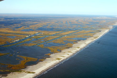 |
| The Wetlands which protect New Orleans from flooding and provide many natural resources are visibly disappearing. (http://media.treehugger.com/assets/images/2011/10/new-orleans-wetlands-disappearing.jpg.492x0_q85_crop-smart.jpg) |
New Orleans dilemma is the product of man-made mistakes. Human processes of pumping and damming
have off set the balance that has kept New Orleans around. Now, while sediment flow should be
compensating for the constant compacting and sinking of the ground surface,
manmade obstructions are slowing that process down and New Orleans is giving up
land, resources, and elevation at an increasing rate.
 |
| This area is the Orleans Metro sub-basin, completely surrounded by water. (http://upload.wikimedia.org/wikipedia/en/thumb/c/ce/Orleans_Metro_sub-basin.jpg/777px-Orleans_Metro_sub-basin.jpg) |
RESOURCES:
- http://environment.nationalgeographic.com/environment/photos/freshwater-rivers/#/rivers07-new-orleans-mississippi_13257_600x450.jpg
- http://www.pbs.org/newshour/rundown/2010/08/in-louisiana-wetlands-erosion-is-slow-moving-crisis.html
- http://books.google.com/books?id=j2gOYK7OJZ4C&pg=PA82&lpg=PA82&dq=New+Orleans+drainage+sub-basins&source=bl&ots=5YsC-OSiOo&sig=tRDKx1J7bdwp04RtcUM3NTIrl9E&hl=en&ei=ARYBTdrJLYKmsQPU64mwCw&sa=X&oi=book_result&ct=result&resnum=4&ved=0CB0Q6AEwAw#v=onepage&q=New%20Orleans%20drainage%20sub-basins&f=false