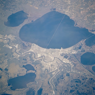
The landscape of New Orleans is one of a kind. New Orleans contains a large portion of
wetlands and has a marshy climate.
One concern that many share for New Orleans is that it is sinking. About 49% of New Orleans is below sea
level and it’s soil, made up of soft sediment, allows for it to continue to sink
deeper.
While many have blamed oil drilling or the nature of the
ground for the sinking, another hypothesis is that tectonic plates cause the
sinking. The Michoud fault goes
through eastern New Orleans and boasts some of the highest subsidence (the
sinking of land) rates in the region.
The fault line occurs where much of the ground is made up of shale and salt,
which are fairly unstable. While
tectonic movement may be responsible for a good deal of sinking, the elevation
of New Orleans and constant flooding causes the soil is also draining while
some of the sediments are being forced together causing compression to occur,
making more room under New Orleans for sinking to occur.
Sinking and flooding are responsible for the geographical
features of New Orleans. There are
marshes and swamps where water has enveloped the land and in areas where land
has completely sunk below water there are lakes and bayous, which are partially
responsible for the humid climate.
This sinking is having drastic effects on the people of New
Orleans. The decreasing elevation
of New Orleans makes it so that populated areas are becoming more and more
susceptible to floods, and the dams and levees that were built to protect the
city are being rendered ineffective by subsidence. Not too long ago, we saw the people of New Orleans
devastated by Hurricane Katrina.
As New Orleans continues to sink, floods will destroy homes and lives.
Sources:
http://www.buzzle.com/articles/geography-of-new-orleans.html
http://www.washingtonpost.com/wp-dyn/content/article/2006/04/02/AR2006040201009.html
http://en.wikipedia.org/wiki/Michoud_fault


No comments:
Post a Comment